The building is fairly central, it is located close to Chinatown (North-East), the CBD (i.e. Central Business District, East), the harbor (South) and Sentosa Island (the pleasure island of Singapore, South-West).
The building is the tallest Award-Winning Residential Development, and consists of seven connected towers. This was Singapore's first 50-storey HDB (Housing Development Board, responsible for building public housing, HDB flat = public housing) building and it is still the world's tallest public housing building. It was constructed between 2005 and 2009. The world's two longest sky gardens of 500 meters are on the 26th and 50th floors.
Entrance for residents is free. For the public the entrance fee is S$5, and payable with EZ link (= travel card ~ OV Chip card).
I, of course, visited the Sky Bridge, on the 50th floor.


It is really built as a garden or communal space for relaxation. The double railing is not bothersome if you want to enjoy the garden.


The 7 towers and 50 floors.


The views are of course amazing. Unfortunately the safety measures often/always get into the way of the pictures...
South, South-West: Jurong Island in the background, the harbor, a little bit of the CBD and other HDBs in the foreground.


Due West:


South-East: CBD.


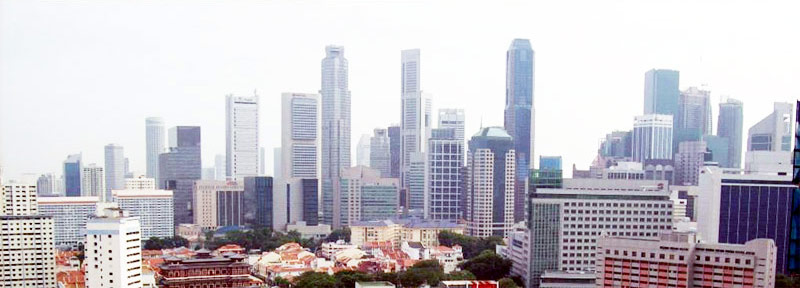
East, North-East: Chinatown and the CBD.

The brownish building in the foreground to the left is Buddha's Tooth Relic Temple. The road in the "middle" going away towards the background is South Bridge Road, one of the first roads built in Singapore (it becomes North Bridge Road and connects Chinatown with the CBD, the administrative district and Kampong Glam, the Malay neighborhood). The original shoreline is the second parallel street to the right/South, Telok Ayer street. And the original Chinatown, or the heart of Chinatown is behind the Relic Temple in streets that run across or horizontally in the picture, Smith, Temple and Pagoda streets.


You can even see the covered walkways in front of the shophouses.


North: Outram Park MRT station, Pearl's Hill City Park, and the rest of Singapore with residential neighborhoods. In the background it is possibly Bukit Timah, Singapore's highest point at 163 meters! (Just so that you know, the lowest point is reported as being the Singapore Strait, Strait of Johor at 0 meters, i.e. sea level.)


Note the amount of greenery in all the pictures. I still have the feeling that these pictures do not do justice to Singapore. My sense of it is that it is much greener!